Flight Around Tasmania 2011

First sunrise 2011 from 5000ft altitude over the Freycinet Peninsula, Tasmania.
Another of my dawn flights on New Years day to greet the sun.
I was probably the first in Australia to see the sun that year.
Too many others nursing sore heads under pillows...
Another of my dawn flights on New Years day to greet the sun.
I was probably the first in Australia to see the sun that year.
Too many others nursing sore heads under pillows...

'Friendly Beaches' airstrip where I took off for that early morning photo.

Camped at Friendly Beaches airstrip.

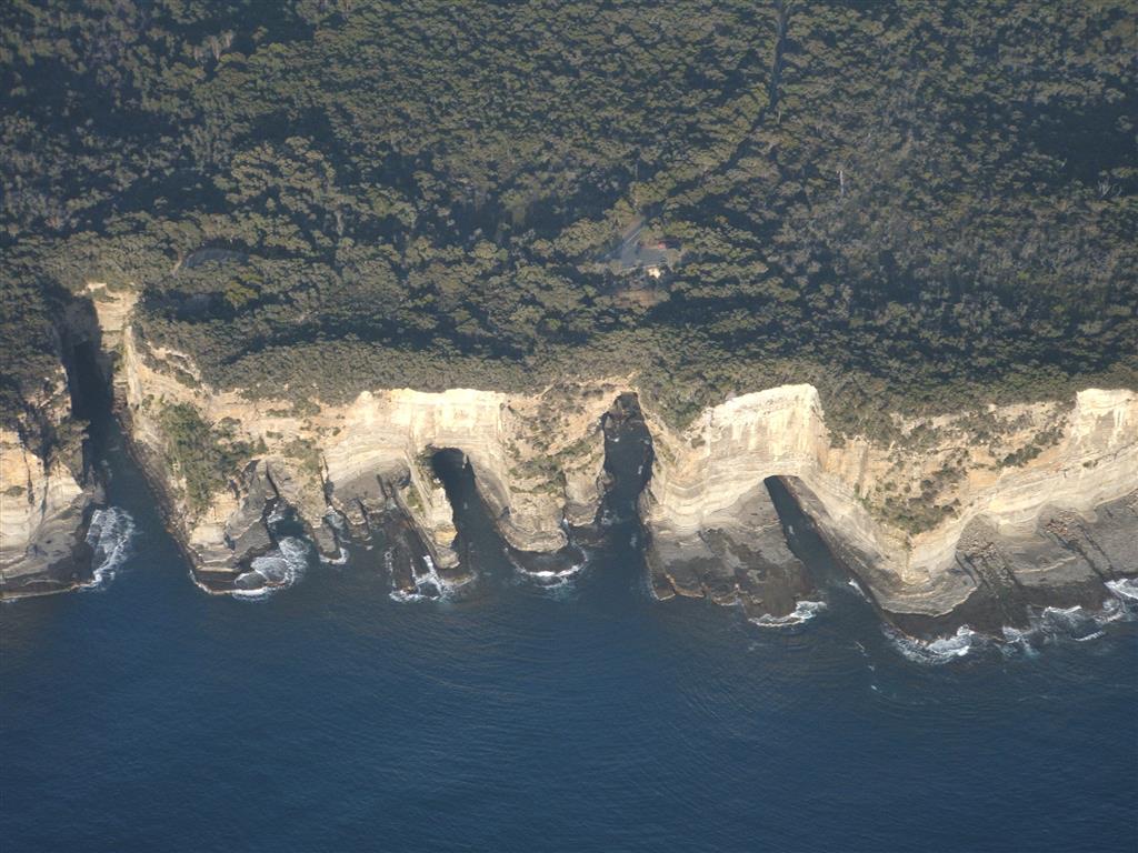
Cape Pillar, he very SE point of Tasmania.

Tasman Island.

A spectacular scene!
Those cliffs are 1000ft high, and very cold water all round....

Port Arthur. Cozy coves to for boats to shelter inside the large harbour.
This was once a brutal prison colony.....

The land to the left is the peninsula where the Port Arthur prison colony was located.
This narrow neck of land is all that connects it with the rest of Tasmania.
The guards had savage dogs chained in a line across that isthmus
to prevent prisoners from escaping by land.
In those days few could swim well enough to cross that channel.

Doo Town, on Pirates Bay. A beautiful spot with maybe some history...
Spectacular sea caves and blowhole nearby.

Cape Barren geese on Maria Island.
I real danger cause they're large and they think they own the airstrip....
Also often kangaroos on the strip, so a precautionary pass is essential....

A typical Tasmanian cray (lobster) fishing boat

Triabunna with airstrip in the paddock beyond.

Camped on Triabunna airstrip. So soft and lush compared to inland Australia.
It's privately owned, but the owner John Salmon is a welcoming host.
who flew many thousands of hours tuna spotting in a 180 and a 337.
Now has a Super Cub to play with.
It's privately owned, but the owner John Salmon is a welcoming host.
who flew many thousands of hours tuna spotting in a 180 and a 337.
Now has a Super Cub to play with.

Camped on Bruny Island.
Sure is good to be self-contained.

The bike was really handy for excursions.
This was riding on Bruny Island to visit the penguin rookery and see the sights,

Self explanatory.
Bullet holes show the need to keep firearms out of reach of common dimwits....

Hobart City looking north.
The antarctic supply ship Aurora Australis at the dock.

Hobart city with Mt Wellington in background.

Salmon Farming


Heading into the western mountains.
Low ceiling and dark and threatening, but distant visibility so not closing in.

'Percipitous Bluff' southern Tasmania.

The airstrip at Bathurst Harbour.
Every morning about 10am a couple of Briton-Norman Islanders and a couple of 206s
come in there to ferry in hikers to walk the spectacular terrain.
The diggings in the foreground are old tin mining activity, now ceased.
No roads any near here.

One of the excellent walking tracks snaking along the range.

Parked at Bathurst Harbour strip.
White shell sand looks like snow, eh.....

Parked at Bathurst Harbour strip.
White shell sand looks like snow, eh.....

Maatsuyker Island, SW corner of Tasmania.
This is unusually fine weather for here. Average 250 a year days wet and windy.

Maatsuyker is the southernmost lighthouse in Australia.
Now manned by volunteers.

Wild desolate beaches of SW Tasmania.

Bathurst harbour.
There's an exit to the ocean in the far distance.
Note the yachts sitting snugly in that very sheltered cove.

The remains of a 4-masted ship that ran aground here long ago.

A fine wilderness river into Bathurst Harbour.

Now headed up over the mountains in the interior.

Federation Peak, the most spectacular of Tassie's mountains.
Very difficult access by foot, through tangled vegetation and often deep mud....
Flying is the way to get a really good view with little effort,
just need to ignore all the 'tiger country' below.....

One of the U-shaped valleys from glacial times.

More pure wilderness.

The King River, one of the wild rivers near the Franklin.
But devoid of life now because it's one of the most toxic polluted rivers anywhere.
Let's follow it upstream and see why.....
But devoid of life now because it's one of the most toxic polluted rivers anywhere.
Let's follow it upstream and see why.....

The small power station on the right is no problem,
but note the brown stain coming in from the Queen River on the left.
but note the brown stain coming in from the Queen River on the left.

The Queen River as it flows out of Queenstown.

The Queen River right through town....
Kids can't play there......
Kids can't play there......

Here's the origin of the stain.
The tailings of the Mt Lyell copper mine.
The mine is long closed down but leaching goes from the tailings....
The tailings of the Mt Lyell copper mine.
The mine is long closed down but leaching goes from the tailings....

The Mt Lyell mine today. Just over the pass is the pristine Lake Burbury.
The actual physical damage of the mine is quite confined, but run-off is a problem,
which has totally poisoned the rivers on this side of the range.
When the smelter was operating the fumes denuded the hillsides....
It's a real mess that could have been prevented by better regulation.....

The tin mine at Waratah. A much tidier operation these days.
This sort of mining can co-exist with the environment.

Note the tidy landscaped town, so different from most mining towns.

A typical beach along the west coast of Tasmania.

'Hobbit' country in northern Tassie.
What a contrast to the wild mountains of the south.
Or even more so the arid interior of so much of Australia.....
What a contrast to the wild mountains of the south.
Or even more so the arid interior of so much of Australia.....

Flying east along the north coast of Tassie I was reading a ground speed of 114 kts
while poking along at an indicated airspeed of 74kts, so that was 39kts tailwind!
It was smooth at 3500ft and great to be blasting along burning only 14litres an hour.
Then I had to turn north to head for Flinders Island, and had to go under this cloud...
And the raging tailwind became a raging X-wind....

Spindrift tells the story, and cold water....

Cape Barren is an Aboriginal settlement and this is their flag showing the wind.....
It was a wild and whoop-t-doo landing in that wind.....

Then found this perfectly sheltered nook to park in.
Perfectly calm in there, but note the trees on the left.....

This Lady Barren, on the south end of Flinders Island.
The strip right next to town.
The strip right next to town.

It's owned by Gordon, who runs an air courier service for the islands.
He has two GA8 Airvans and a 206, and is busy moving freight around the islands.

The next three photos show a panorama of the view from the pub.
It would have to be one of the best pub views in the country.
And the locals do spend a lot of time here enjoying it.......

That island right in front now owned by Russians....

